

Discover more from Mind the Moss
And suddenly, the waterfalls disappeared
Chasing Fall River's lost subterranean cascades
If you’ve ever set foot in an American city, you’ve probably had the strange experience of stumbling upon a park or a transit center named after a pleasant-sounding river or stream, only to find no such waterway within sight. A few years back, my subway stop here in Boston was Stony Brook station, along the MBTA’s Orange Line. The station is located right on a pedestrian and cyclist greenway flanked by triple deckers. But any trace of a stony brook that once existed in this area of Boston has long since dried up.
Or has it?
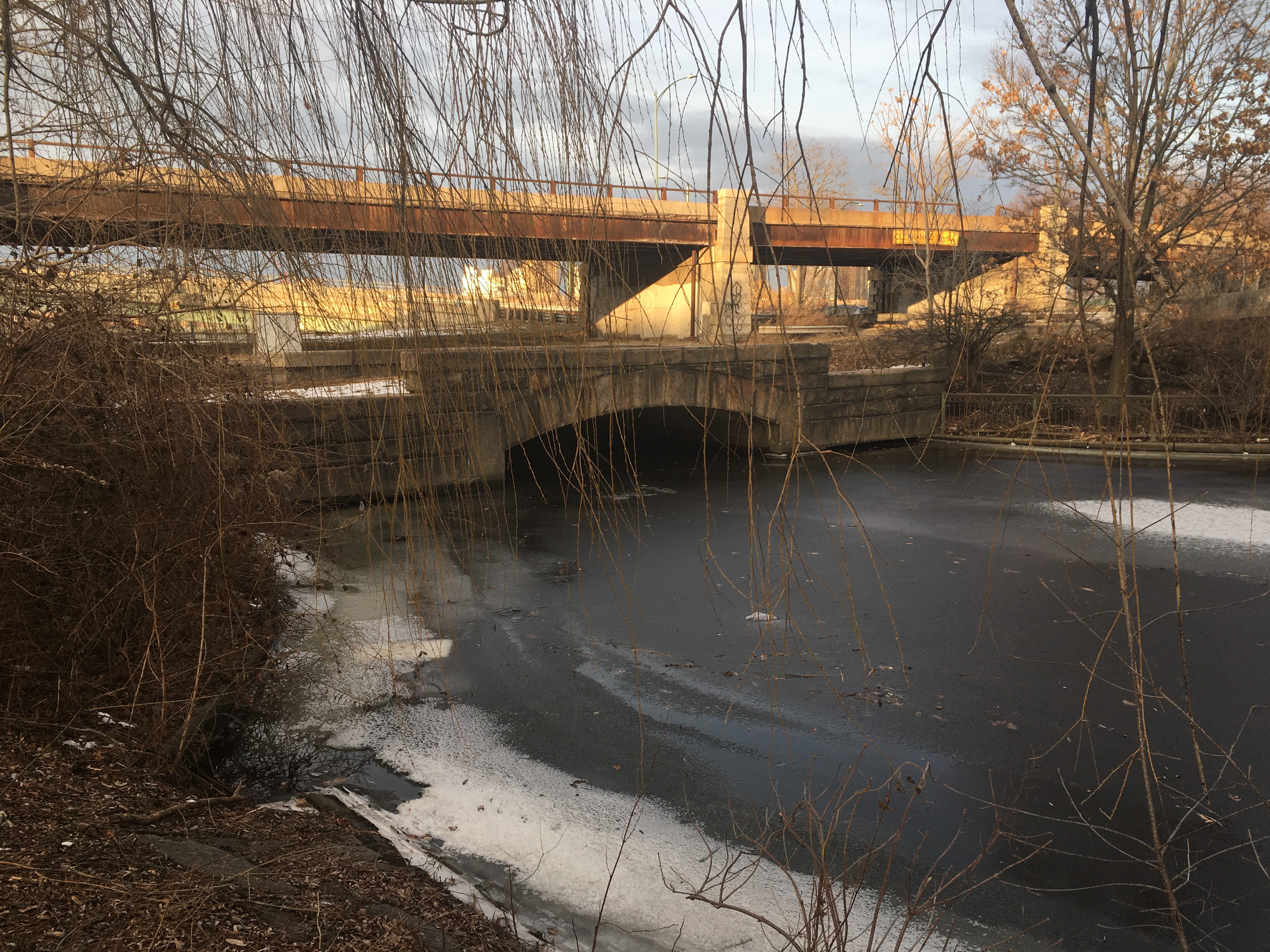
Not too long ago, I found out that Stony Brook is a real, active waterway that flows more than 8 miles beneath the city of Boston. It starts from Turtle Pond, in the woods near Dedham, and bubbles beside a busy parkway for half a mile before disappearing into a culvert. From here, the brook sloshes beneath Roxbury and Jamaica Plain through conduits before emptying into the Charles River. Adam Gaffin of Universal Hub called Stony Brook “Boston’s Stygian river” in an impressively detailed historic account of how Boston decided to re-route the naturally occurring brook into long underground pipes. (The brook caused flooding around Roxbury during the spring.)
It’s rather eerie to imagine these lost rivers churning beneath our feet as we amble around cities like Boston or New York—the latter of which is now unearthing one of these subterranean streams. Tibbetts Brook, which flows under The Bronx, is going to be exhumed by the city over the next few years. The conceit is that “daylighting” the forgotten brook will prevent flooding in the sewer system by creating more open-air reservoirs for excess waters during coastal storms. But the daylit brook could also be paired with new public green spaces that offer multi-use trails and rejuvenated flora.
Daylighting projects are happening in major cities across the world, from Seattle to Seoul. But it’s not just the major cities that stand to benefit from restoring their lost rivers. One of the most dramatic examples of a city covering up its watery features is rooted in Fall River, Massachusetts. Many people are familiar with Fall River due to its once booming textile mills and for its rich history of true crime (Lizzie Borden lived here, as did the murderous cultists who helped fuel the Satanic Panic of the 1980s.) Less spotlit is the Quequechan River, which ripples northwest from South Watuppa Pond through central Fall River. The word “quequechan” is Wampanoag for “falling waters” or “falling river.” And sure enough, the Quequechan River includes several waterfalls that occur right where the Quequechan runs through downtown Fall River.
But you can’t see them. The waterfalls were re-routed into culverts during the 1960s as the state constructed the interstate highway I-95. For decades, the disappearing falls have rumbled away in solitude beneath the city. Even in 2015, when Fall River decided to improve pedestrian access to the Quequechan by building the Alfred J. Lima Rail Trail along 1.4 miles of the riverbanks, the falls of Fall River remained underground.
So naturally, I decided to go there and chase them—to find whatever traces I could.
I started my investigation at the Rail Trail itself, where it crosses Quequechan Street and runs parallel to I-95 and the river. It’s…not the most inviting trailhead. The entry point is overshadowed by this enormous billboard which was displaying an ad for Weight Watchers at the time of my hike, and the sidewalks near the trailhead were colorfully littered with broken glass. But as you head west on the trail, something neat happens. The trail runs atop a long sliver of land that extends across the center of the Quequechan, with some boardwalk to bridge the occasional patches of reedy wetland. You’ve got the river on both sides and the rumbling of the highway feels a little more distant. It certainly doesn’t intimidate the local ducks, of which there are hundreds. As I strolled toward downtown Fall River, shivering, I watched a few of these ducks swim through narrow channels of melted water amid the half-frozen river before extricating themselves and marching across the ice. I had already forgotten the broken glass.
A forked section of boardwalk marks the point where the Quequechan starts to vanish into thicker reeds and then, down into the subterranean pipes. I turned left, passing under the highway and ending up on Rodman Street. From here, the relative natural scenery faded to fast food joints, auto yards, and abandoned buildings, boarded up and waiting for new life. I was roughly one mile into the hike, mindful that it would be an out-and-back journey as soon as I found some remnant of the lost waterfalls.
This wasn’t a totally blind foray. A bit of online sleuthing before my hike suggested that I might get lucky at an old factory on Anawan Street. (It’s not often that you can write that sentence.) So I pushed onward, looking in both directions at hectic road crossings and finding a few surprises along the way. This is one of the perks of urban hiking—discovering curiosities like a city hall literally built atop the local highway. Or a shining silver sculpture on the same building, commemorating the region’s indigenous peoples, immigrants, refugees, and the formerly enslaved. Who knows what I missed.
As the highway disappeared beneath city hall, the vast of the Taunton River suddenly appeared ahead and the street descended toward it at a moderately steep grade. This was a good sign. The Quequechan flows into the Taunton River. So if I was heading downhill to reach the Taunton, the Quequechan would have to make the descent too. Waterfalls would occur right around here. I felt like Crockett or Tubbs closing in on a suspect along the Key Biscayne causeway as I walked beneath an overpass on Anwan Street. Here, I found myself at an lonely looking parking lot. But amid the sounds of the city—grumbling traffic, the hissing of steam from furnaces—I could hear water. I walked over to a concrete barrier wall and peeped through its rusty chain link fence.
For a few yards, the lost falls emerged from a culvert, spilling down into yet another culvert and vanishing once again beneath an old mill building. I did a little jig right there in the parking lot, having found an exposed section of Fall River’s disappearing cascades! I couldn’t help but notice that inside the mill building, there were people on treadmills, burning calories under fluorescent lights while the lost cascade rumbled away just outside, continuing under the fitness center on its way to the Taunton River.
But was this it? Were there more exposed waterfalls to be found around here?
I started to snoop around the mill building complex, wandering past loading docks and parked vans, trying not to attract attentions. And just a few paces away from one of the loading docks, in the center of the complex, my snooping was heftily rewarded.
Imagine how many people must drive past the mill building on Anawan Street each day—on local roads or the interstate—not knowing that these lost waterfalls make cameo appearances right here, in the literal shadows of industrial buildings. You’d think any city would want to spotlight such natural beauties and make them more accessible for visitors. And in Fall River, that might just happen. Over the last few years, there’s been ongoing conversation about unearthing and restoring these waterfalls to their natural flow. In 2019, a local environmental nonprofit called Green Futures presented the Massachusetts Department of Transportation with a plan for daylighting the falls on the Quequechan where the river crashes down the hillside to the Taunton River. It remains to be seen whether the state will fund this project, but if enough Fall River residents ask for it (the 2019 proposal had considerable local support) the shovels might be deployed here in the near future and the lost waterfalls could be set free.
Since this was a custom hike, I created a map of my 2.4 mile route on AllTrails. CLICK HERE TO VIEW AN ALLTRAILS MAP OF THE HIKE. If you’d rather plug the location of the falls into Google Maps and cut your own path there, CLICK HERE FOR A GPS PIN.
This story about daylighting waterways didn’t come out of nowhere. I spent the last few weeks reporting and writing a feature for The Boston Globe that looks at a very exciting daylighting project which is happening in Boston on the Emerald Necklace.
Readers: I need your help. My roommate and I recently started watching Yellowjackets and in honor the series, I want to take a hike someplace in New England where there have been confirmed reports or even rumors of cannibalism occurring. Given all the trails around this region that are named after the devil, we’ve gotta have at least one trail with a history of femur gnawing, right? Please reply with any ideas. I’ll take ‘em!
Finally, as a former LA resident—I lived there from 2007 to 2011—I loved this Financial Times column by Janan Ganesh about why LA is the essential “walking city.” Yes, car culture still dominates the SoCal metropolis. Voluntarily walking LA streets makes you something of a freak. But the stuff I saw while stalking around LA felt like glimpses of an unmade David Lynch movie. I remember a shopping cart full of VHS tapes, a whole sidewalk of Mountain Dew bottles which contained something that definitely was not Mountain Dew (but probably no worse) and at one point, a loose dog that looked like a shetland pony. Between its eccentricities and its sunny weather, LA is the ultimate place for being a flâneur, which is the French word for “saunterer.” Personally, I prefer the poet Charles Baudelaire’s interpretation of the word—“a botanist of the pavement.”
By the way, I’ll be visiting LA in late February and I’ll be taking at least two urban hikes while I’m there. You heard it here first. The newsletter is going on a regional field trip!